Sakonnet – Little Compton Coast Walk
I’ve been exploring Rhode Island’s gorgeous coastline recently. Considering how hot and humid it’s been this summer, it made perfect sense to do so. What better way to escape the heat than to be down by the shore? After all, this is the Ocean State and going to the beach is a time honored Rhode Island tradition, practiced by thousands on hot summer days, who flock to the coast to enjoy the scenery, cool breezes, refreshing salt water and the waves. What could be better than this?
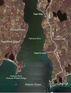
 While I enjoy going to the beach as much as anyone, I’m not satisfied to just sit on the sand and splash around in the surf. I need to walk and explore. And that’s what I’ve been doing, focusing my attention this summer on the coast of Aquidneck Island, walking its beaches as well as hiking along the rocky coastline, which there’s plenty of on the island. Earlier in the season a friend and I walked the east shore of Portsmouth, going south from Teddy’s Beach in Island Park to Sandy Point. What a beautiful, rugged coast we encountered. The views along the Sakonnet River were stunning and spectacular. For those who don’t know, this is not a river but a substantial inlet of the sea. Always in view on the other side of the Sakonnet were the towns of Tiverton and Little Compton. And more coastline, lots of it, actually, miles of it. As we walked that day, I kept looking towards the other side and thinking how much I would enjoy walking on what appeared, from where I stood, to be a beautiful shore. In subsequent days, the notion of going there became irresistible, so I made plans. One day last week the tides were low at the right time and I went. While the weather wasn’t perfect, it was good enough. I parked at the end of Town Way, a town road off West Main Road, Route 77, in the north end of Little Compton. There’s coastal access here and a legal place to park. I then walked south along the rough, rocky shore for a little more than 3.5 miles (5.6 kilometers) to Taylor’s Lane, a town road, also off West Main Road. There’s a coastal access point and legal place to park here too. I saw fewer than 10 people on my trek, some fisherman and a few beach combers out enjoying a sultry, overcast summer day.
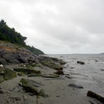
Nature reigns here. This is a remote, isolated part of the coast, mostly due to the ruggedness of the shore and because there’s no public coastal access between Town Way and Taylor’s Lane. There are few houses here, all are set back from the bluff and mostly hidden from view. And no sandy beaches. If there were, they would naturally attract your typical beach loving Rhode Islander. Just lots of stones here, predominantly Narragansett Basin sedimentary rock, including sandstone and conglomerate. Sandstone is just that, stone made up of particles of sand. The conglomerates found here are composed of rounded pebbles of various sizes, densely packed and cemented together with sand. According to geologists, the sand and pebbles originated in nearby, long disappeared mountains that once existed close by, if you can imagine that. The sand and pebbles flowed out of the mountains and settle in lowlands during the coal age over 300 million years ago. They built up in layers until the accumulations were thousands of feet thick. Here, they fused together into solid rock under the pressure of the Earth, only to be exposed by erosion all these hundreds of millions of years later. The countless number and variety of rocks littering the shore helped to make this a hard, strenuous walk. In fact, it was one of the more difficult hikes I’ve taken in Rhode Island. But the visual rewards along with the interesting geology and opportunity to walk along miles of rural coastline more than made up for the grueling nature of the route. As I headed south and got closer to the Atlantic Ocean, which was visible in the distance between Little Compton and Sachuest Point National Wildlife Refuge in Middletown, the influence of the sea increased, as did the height of the waves. Since I was hiking alone, once I reached Taylor’s Lane I had to turn around and retrace my way back to Town Way. It was as scenic returning as it was coming. Unfortunately, my camera gave out soon after I started my walk, so I wasn’t able to get pictures of the more spectacular coastal scenery I encountered along the way. But I’ll have another opportunity to take photos when I return there, which will be sooner rather than later.
If you go, be sure to consult the Sachuest, Flint Point, Sakonnet River tide chart beforehand and walk at low tide, otherwise you could run into difficulty on this wave battered rocky shore. Wear water shoes since it’s possible you may have to walk in the sea at some point. And keep below the highest tide line, otherwise you’ll be trespassing on someones property. Also, along the way there are a number of privately-owned stairways leading from the shore up the embankment, as well a few footpaths that go inland, all of which you should not enter. For the coast walkers among you, this scenic route comes highly recommended.
(click on images for larger view)
